Ages: Colin was 71 years and 335 days. Rosemary was 69 years and 112 days.
Weather: Bright sunshine, but a cold wind.
Location: Towyn (Tudweiliog) to Whistling Sands.
Distance: 9 miles.
Total distance: 3636 miles.
Terrain: A little sandy beach, but mainly clifftop paths which were grassy and muddy. It was slippery, very undulating and badly signed — very challenging walking and I had difficulty in coping. We got lost, ‘escaped’ through a farm, and then marched a couple of miles of tarmacked lane. At the end we walked over the squeaking sands of Whistling Sands Bay.
Tide: Out, coming in.
Rivers: None.
Ferries: None.
Piers: None.
Kissing gates: Nos.710 to 721 (12 in all) on the cliff tops.
Pubs: None.
‘Cadw’ properties: None.
Ferris wheels: None.
Diversions: None.
How we got there and back: We were staying in our caravan in Snowdonia. This morning we drove to Aberdaron where we parked the car up a steep road for free because the car park would have cost us nine pounds for the day! From there we caught a bus to Tudweiliog, where we walked across muddy fields to Towyn.
At the end we got to Whistling Sands where we had had enough! We failed to find anybody who could give us a lift to Aberdaron, so we route-marched it along the roads — two and a half miles in 55 minutes, not bad for two tired old fogies! We had our tea and biscuits, then drove back to our caravan.
 I felt much more lively today, I don’t know why I felt so lacking in
energy yesterday. It was good to see the
sun though it was cold in the wind on the cliff tops. We really enjoyed the first part of this
Walk. We started at a sandy beach, but
there was no way off it at the other end so we had to content ourselves with
walking through the mud at the top instead of along the sand.
I felt much more lively today, I don’t know why I felt so lacking in
energy yesterday. It was good to see the
sun though it was cold in the wind on the cliff tops. We really enjoyed the first part of this
Walk. We started at a sandy beach, but
there was no way off it at the other end so we had to content ourselves with
walking through the mud at the top instead of along the sand.
 The terrain was challenging with loads of mud, but we hadn’t
washed off yesterday’s so we just added to it on our boots and trousers! The gullies seemed deeper and the ways out of
them more slippery than yesterday, but we coped. I was really glad I had remembered my walking
poles today. There was a caravan site
nestling in one of the gullies, but I wouldn’t have liked to leave my van there
— it was too exposed to the elements.
The terrain was challenging with loads of mud, but we hadn’t
washed off yesterday’s so we just added to it on our boots and trousers! The gullies seemed deeper and the ways out of
them more slippery than yesterday, but we coped. I was really glad I had remembered my walking
poles today. There was a caravan site
nestling in one of the gullies, but I wouldn’t have liked to leave my van there
— it was too exposed to the elements.
 It was very clear today, unlike yesterday. The scenery was dramatic and wonderful! Colin said one of the rocks was really an
iguana! Some of the streams running in
spate had lost their stepping stones, or they never had them in the first
place. Either way, we managed to
overcome the difficulties without filling our boots with water!
It was very clear today, unlike yesterday. The scenery was dramatic and wonderful! Colin said one of the rocks was really an
iguana! Some of the streams running in
spate had lost their stepping stones, or they never had them in the first
place. Either way, we managed to
overcome the difficulties without filling our boots with water!
 As we climbed out of one gully, we were
completely out of the wind and it was so beautiful that we sat on rocks and ate
our quiches.
As we climbed out of one gully, we were
completely out of the wind and it was so beautiful that we sat on rocks and ate
our quiches.
 We didn’t want to move from
there it was so peaceful, and as soon as we reached the top we were exposed to
the elements again. There were
celandines in full flower everywhere we looked, so it really is Spring despite
the windy weather.
We didn’t want to move from
there it was so peaceful, and as soon as we reached the top we were exposed to
the elements again. There were
celandines in full flower everywhere we looked, so it really is Spring despite
the windy weather.

 We made very slow progress.
Eventually we came to a sandy bay which was over a mile long — but we couldn’t
see a way down to it until we were halfway along. There we had a choice of continuing along the
top or taking a path down on to the sands.
We hadn’t seen any blue logo signs for ages. The path along the top was flat, so we chose
that. We came to a fence, and the only
gate through it took us down to the lower path — should we have been down there
all the time? There were no signs of any
kind to help us. Another gate led us on
to the beach.
We made very slow progress.
Eventually we came to a sandy bay which was over a mile long — but we couldn’t
see a way down to it until we were halfway along. There we had a choice of continuing along the
top or taking a path down on to the sands.
We hadn’t seen any blue logo signs for ages. The path along the top was flat, so we chose
that. We came to a fence, and the only
gate through it took us down to the lower path — should we have been down there
all the time? There were no signs of any
kind to help us. Another gate led us on
to the beach.
 We looked at the map and guessed we were just a bit south of
a car park. We concluded we would have
to go round a rock on the beach, then climb up again. It was a lovely sandy beach in the middle of
nowhere. But, because there was a car
park, a few people were about playing with their dogs.
We looked at the map and guessed we were just a bit south of
a car park. We concluded we would have
to go round a rock on the beach, then climb up again. It was a lovely sandy beach in the middle of
nowhere. But, because there was a car
park, a few people were about playing with their dogs.
We went round the rock and came to a steep track leading upwards. The trouble was, a stream was running down it and bits were missing! It was difficult to negotiate, but we got up it. At the top we came across the first blue coast-path arrows we had seen in a long time, and they were directing us back down the very track we had just come up! We should have been on the top all the time, and now we had to go back down, round another rock before coming up. We were furious at the confusing signage.
It was much more difficult going down the broken path — I was terrified of slipping. We wished we could stay on that lovely beach, but we couldn’t guarantee being able to get off it at the further end. So we crossed a stream and climbed steps the other side. I was tired and fed up, and insisted we sat on a grassy knoll for a rest. I ate just one of my sandwiches, for some reason I didn’t feel very hungry. We could see a stream falling over quite a nice series of little waterfalls.
We climbed a very steep slope to the top of the cliff — I needed Colin to haul me up some of the steps, and I wouldn’t have managed it without my poles. There was a proper seat at the top, the only seat we passed on the whole of the Walk. When we eventually got to the end of the long bay (up & down, up & down) we found we could have walked the whole way along the beach after all! We must have wasted at least half an hour not doing that.
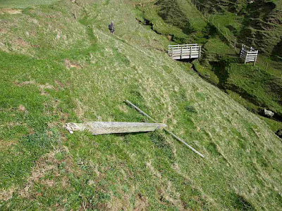
 We had another couple of miles of clifftop walking to do
which took us ages because of all the
gullies we had to walk down, then up the other side. But at least we had half-decent bridges —
some very decent — to enable us to get across the streams which were rushing
down in spate.
We had another couple of miles of clifftop walking to do
which took us ages because of all the
gullies we had to walk down, then up the other side. But at least we had half-decent bridges —
some very decent — to enable us to get across the streams which were rushing
down in spate.
We knew the Coast Path turned inland at one of the gullies and then followed a parallel road for a while. Each gully we came to I asked, “Is this our gully?” but the blue logos pointed us on to the next one. We came, at last, to one where the signpost had fallen over so we didn’t know in which direction it had originally been pointing. “Surely this is our gully!” I said in despair, for I was really quite tired by then. But a blue logo on the bridge definitely pointed us to go on.
 Because of the terrain, it was difficult to see whether there
were any paths in any direction. We
followed a ‘sort-of’ path in the direction of the arrow, over a knoll and along
quite a way to the next gully. There were no Coast Path signs or logos to
be seen anywhere! Colin went to
the edge of the gully and said there was a bridge down the bottom and a
signpost, lurching at an angle, halfway up the other side. This post had a yellow arrow on it, not the
blue coast-path logo. There was nothing
on the bridge. We carried on, but the
path seemed to disintegrate and I was not at all happy. We needed to go inland and find the road.
Because of the terrain, it was difficult to see whether there
were any paths in any direction. We
followed a ‘sort-of’ path in the direction of the arrow, over a knoll and along
quite a way to the next gully. There were no Coast Path signs or logos to
be seen anywhere! Colin went to
the edge of the gully and said there was a bridge down the bottom and a
signpost, lurching at an angle, halfway up the other side. This post had a yellow arrow on it, not the
blue coast-path logo. There was nothing
on the bridge. We carried on, but the
path seemed to disintegrate and I was not at all happy. We needed to go inland and find the road.
 I insisted we got out the map again (why is Colin always so
reluctant to do this? Is it a ‘man’
thing?) and realised that the gully with the fallen signpost was our gully! We were well beyond it where no path is
marked on the OS map. Even Colin had to
admit this. He saw a gate right at the
top of the cliff, so we back-tracked and climbed up an almost vertical grassy slope
— thank goodness for my walking poles! By
zigzagging we were able to scramble up the landslips, and Colin heaved me up
the hardest bits. At least the gate
opened when we got there, so we didn’t have to climb over it.
I insisted we got out the map again (why is Colin always so
reluctant to do this? Is it a ‘man’
thing?) and realised that the gully with the fallen signpost was our gully! We were well beyond it where no path is
marked on the OS map. Even Colin had to
admit this. He saw a gate right at the
top of the cliff, so we back-tracked and climbed up an almost vertical grassy slope
— thank goodness for my walking poles! By
zigzagging we were able to scramble up the landslips, and Colin heaved me up
the hardest bits. At least the gate
opened when we got there, so we didn’t have to climb over it.
But our troubles were not over yet. In front of us was a flat field with a farm in the distance. We walked inland beside the gully, but at the end of the field there was no way out, just barbed wire fences, and I really feel I am now too old to climb over barbed wire fences! There was a gate down in the gully, but we couldn’t see a way out once we had got past it. There seemed to be fences everywhere. Then Colin noticed that one of the fences beyond the gully was a single strand of plain wire. So we scrambled down and climbed over the gate which obviously hadn’t been used in years and was completely weeded in. We climbed the other side of the gully and dipped under the single-strand fence. We looked around. I noticed a gate in the opposite diagonal corner of the field we were now in, and had a hunch there was a track on the other side of it. There was! The track led us round past the farm and eventually out on to the road. We had escaped!
Relief! According to the OS map, the next 2km of this road was the official coast path, but there were no signs! We walked it quickly, much more efficiently than the cliff top path, but it was boring! There was no traffic. We turned on to a waterlogged track, but we were used to waterlogged paths by now — we both had mud splattered up well above our knees. We got back to the coast at the top of Whistling Sands. There we came across the first Coast Path sign in miles — on top of the cliff and pointing in both directions! Aaarrgh!

 We descended through a rubbish-strewn cutting on to the
sands. There we spent a pleasant twenty
minutes or so making the sand squeak under our feet! There were several landslips on the soft
cliffs, some looked quite recent. We sat
on the end of a broken-off road and ate the rest of our lunch though it was now
evening. We idly watched a youth group
playing football on the beach, and decided to end our Walk there because it was
far too late in the day to walk on to Aberdaron where we had parked our car
this morning. We walked up the road to
the car park hoping we could cadge a lift off someone to Aberdaron.
We descended through a rubbish-strewn cutting on to the
sands. There we spent a pleasant twenty
minutes or so making the sand squeak under our feet! There were several landslips on the soft
cliffs, some looked quite recent. We sat
on the end of a broken-off road and ate the rest of our lunch though it was now
evening. We idly watched a youth group
playing football on the beach, and decided to end our Walk there because it was
far too late in the day to walk on to Aberdaron where we had parked our car
this morning. We walked up the road to
the car park hoping we could cadge a lift off someone to Aberdaron.

That ended Walk no.352, we shall pick up Walk no.353 next time in Whistling Sands car park at the top of the cliffs. It was twenty-five past six, so the Walk had taken us eight hours ten minutes. We had had enough! The walking had been much tougher than we had anticipated, and I was all in. We asked the driver of the one and only car parked at Whistling Sands if he could give us a lift to Aberdaron, but he was going the other way. So we route-marched it along the roads – two and a half miles in 55 minutes, not bad for two tired old fogies! (We were not passed by a single vehicle going our way, and precious little going the other.) We had our tea and biscuits, then drove back to our caravan.
We have decided to break up this Trek into more ‘bite-size’ chunks and have more rest days in between. Otherwise we pretty soon won’t be enjoying it, and that is the whole point. We don’t need to go so madly at it, now we’ve finished with Scotland and are much nearer home.
Location: Towyn (Tudweiliog) to Whistling Sands.
Distance: 9 miles.
Total distance: 3636 miles.
Terrain: A little sandy beach, but mainly clifftop paths which were grassy and muddy. It was slippery, very undulating and badly signed — very challenging walking and I had difficulty in coping. We got lost, ‘escaped’ through a farm, and then marched a couple of miles of tarmacked lane. At the end we walked over the squeaking sands of Whistling Sands Bay.
Tide: Out, coming in.
Rivers: None.
Ferries: None.
Piers: None.
Kissing gates: Nos.710 to 721 (12 in all) on the cliff tops.
Pubs: None.
‘Cadw’ properties: None.
Ferris wheels: None.
Diversions: None.
How we got there and back: We were staying in our caravan in Snowdonia. This morning we drove to Aberdaron where we parked the car up a steep road for free because the car park would have cost us nine pounds for the day! From there we caught a bus to Tudweiliog, where we walked across muddy fields to Towyn.
At the end we got to Whistling Sands where we had had enough! We failed to find anybody who could give us a lift to Aberdaron, so we route-marched it along the roads — two and a half miles in 55 minutes, not bad for two tired old fogies! We had our tea and biscuits, then drove back to our caravan.


We went round the rock and came to a steep track leading upwards. The trouble was, a stream was running down it and bits were missing! It was difficult to negotiate, but we got up it. At the top we came across the first blue coast-path arrows we had seen in a long time, and they were directing us back down the very track we had just come up! We should have been on the top all the time, and now we had to go back down, round another rock before coming up. We were furious at the confusing signage.
It was much more difficult going down the broken path — I was terrified of slipping. We wished we could stay on that lovely beach, but we couldn’t guarantee being able to get off it at the further end. So we crossed a stream and climbed steps the other side. I was tired and fed up, and insisted we sat on a grassy knoll for a rest. I ate just one of my sandwiches, for some reason I didn’t feel very hungry. We could see a stream falling over quite a nice series of little waterfalls.
We climbed a very steep slope to the top of the cliff — I needed Colin to haul me up some of the steps, and I wouldn’t have managed it without my poles. There was a proper seat at the top, the only seat we passed on the whole of the Walk. When we eventually got to the end of the long bay (up & down, up & down) we found we could have walked the whole way along the beach after all! We must have wasted at least half an hour not doing that.

We knew the Coast Path turned inland at one of the gullies and then followed a parallel road for a while. Each gully we came to I asked, “Is this our gully?” but the blue logos pointed us on to the next one. We came, at last, to one where the signpost had fallen over so we didn’t know in which direction it had originally been pointing. “Surely this is our gully!” I said in despair, for I was really quite tired by then. But a blue logo on the bridge definitely pointed us to go on.


But our troubles were not over yet. In front of us was a flat field with a farm in the distance. We walked inland beside the gully, but at the end of the field there was no way out, just barbed wire fences, and I really feel I am now too old to climb over barbed wire fences! There was a gate down in the gully, but we couldn’t see a way out once we had got past it. There seemed to be fences everywhere. Then Colin noticed that one of the fences beyond the gully was a single strand of plain wire. So we scrambled down and climbed over the gate which obviously hadn’t been used in years and was completely weeded in. We climbed the other side of the gully and dipped under the single-strand fence. We looked around. I noticed a gate in the opposite diagonal corner of the field we were now in, and had a hunch there was a track on the other side of it. There was! The track led us round past the farm and eventually out on to the road. We had escaped!
Relief! According to the OS map, the next 2km of this road was the official coast path, but there were no signs! We walked it quickly, much more efficiently than the cliff top path, but it was boring! There was no traffic. We turned on to a waterlogged track, but we were used to waterlogged paths by now — we both had mud splattered up well above our knees. We got back to the coast at the top of Whistling Sands. There we came across the first Coast Path sign in miles — on top of the cliff and pointing in both directions! Aaarrgh!


That ended Walk no.352, we shall pick up Walk no.353 next time in Whistling Sands car park at the top of the cliffs. It was twenty-five past six, so the Walk had taken us eight hours ten minutes. We had had enough! The walking had been much tougher than we had anticipated, and I was all in. We asked the driver of the one and only car parked at Whistling Sands if he could give us a lift to Aberdaron, but he was going the other way. So we route-marched it along the roads – two and a half miles in 55 minutes, not bad for two tired old fogies! (We were not passed by a single vehicle going our way, and precious little going the other.) We had our tea and biscuits, then drove back to our caravan.
We have decided to break up this Trek into more ‘bite-size’ chunks and have more rest days in between. Otherwise we pretty soon won’t be enjoying it, and that is the whole point. We don’t need to go so madly at it, now we’ve finished with Scotland and are much nearer home.

No comments:
Post a Comment